My apologies for not posting anything for awhile but I’ve had some personal issues that I needed to take care of . So….. enough of that I’m back now and hope to contribute on a regular basis.
Let me seeee… We left off with the wonderful world of Spatial and me ranting about ESRI. I want to continue with the Spatial stuff but I wanted to share with you guys a more intriguing (at least in my opinion) turn of events. Even though this is totally out of my job description, in my shop we have to do what it takes to get the job done even if that means doing *shutter* development work.
We recently had a complaint from one of our customers that in certain parts of a country that his equipment couldn’t send or receive a satellite signal due to terrain obstacles and he would like to be able to see on the webmap those areas that are “blacked out” so he can avoid them. Well, since we’re all about keeping the customer happy I was tasked to “Make it happen”.
The first step in the process is getting the elevation data of the desired location, once you have the elevation, you find out which satellite your equipment is using. Once you know the satellite, you find out what the Lat/Log and height (location and distance above the earth) of it is.
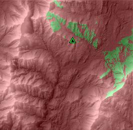
When we have all that information we start piecing the puzzle together. We have to create physical objects in the database like a shape file (our satellite) and a Raster image ( our map) and input all the data that we gathered up (elevation, lat/log, height) once all the values are given we use a tool to calculate the black out areas. The example above, I’ve used an observation tower as an example. The red areas are not visible from the observers view but the green areas are. Get it?
This website gives you in real time all satellite names, and locations using a nice little java thingy. http://science.nasa.gov/RealTime/JTrack/3D/JTrack3D.html


1 comment:
Now I understand why java folk think they are the heavenly hosts. Very cool.
Post a Comment